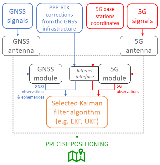
The HYPER-5G product is a “hybrid” positioning algorithm and its software implementation, exploiting multi-constellation GNSS PPP-RTK-augmented observations as well as range and angle observations derived from the transmission and reception of 5G signals.
The product enables the joint exploitation of GNSS, the state-of-the-art technology for positioning applications, and 5G, the future of communication networks, for improved positioning purposes, with the aim of overcoming the limits and enhancing the advantages that characterize the two technologies taken individually.
Depending on the chosen architecture, the product will be used either on the user device (where the GNSS, 5G and in general the PNT equipment resides) or on the 5G/GNSS infrastructure side, to provide hybrid positioning based on the joint use of PPP-RTK-corrected GNSS observations and 5G observations.
The 5G technology and infrastructure are growing rapidly all over the world. The first developers that will manage to have a working hybrid positioning engine will have a unique occasion to sell such a product to several early adopters in different markets and geographies. The development of a hybrid approach for positioning purposes based on 5G and GNSS will be the first step towards a wider integration of different emerging technologies for PNT (e.g. satellites swarms low Earth orbit).
The proposed product is addressing all the sectors for which precise positioning is or will be a fundamental asset (e.g. smart mobility, autonomous driving, emergency services, pedestrian indoor/outdoor navigation, logistics, smart devices-related applications). It is expected that precise positioning, currently limited to professional fields such as topographic / geodetic surveys, precision agriculture or monitoring of landslides or critical infrastructures, will undergo exponential growth with the advent of autonomous driving of cars, drones, robots and the technological development of smart devices.
The product is a “hybrid” positioning algorithm and its software implementation exploiting multi-constellation GNSS PPP-RTK-augmented observations as well as range and angle observations derived from the transmission and reception of 5G signals. The role of the product is to enable the joint exploitation of GNSS, the state-of-the-art technology for positioning applications, and 5G, the future of communication networks, for positioning purposes with the aim of overcoming the limits and enhancing the advantages that characterize the two technologies taken individually.
The verification approach in the product development follows two phases. A first phase lasting from T0+3M to T0+9M (corresponding to work package H5G -012 “Experimental activity definition”) during which the experimental activities will be defined in order to guarantee a complete, accurate and robust validation. This will be done in parallel with the product design phase, in order to receive continuous feedback from the design work packages and keep the experimental activity definition in line with the design solutions adopted.
The experimental activity schedule will be carefully planned and organized in order to effectively carry it out in the last 5 months of the project.
The second phase will start at T0+20, last until the end of the project (T0+24M), and see the actual carrying out of all the experimental activities previously defined, continuously feeding back the implemented system in order to fine-tune them and take them to the end of the project in a manner that is consistent with the validated performance.
The required systems for the provisioning of precise positioning to users based on a hybridization of GNSS and 5G information are reported below. They include GNSS satellites that provide GNSS observations to both end-user devices and 5G communication infrastructure, the latter in charge of guaranteeing wireless connections and, most notably for our purposes, positioning observations over 5G signals. It follows that the user's hardware availability consists of GNSS and 5G equipment, which can be easily integrated on the same device.
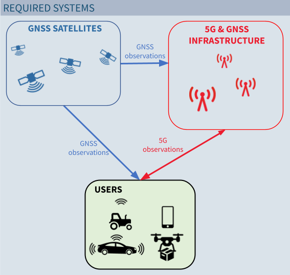
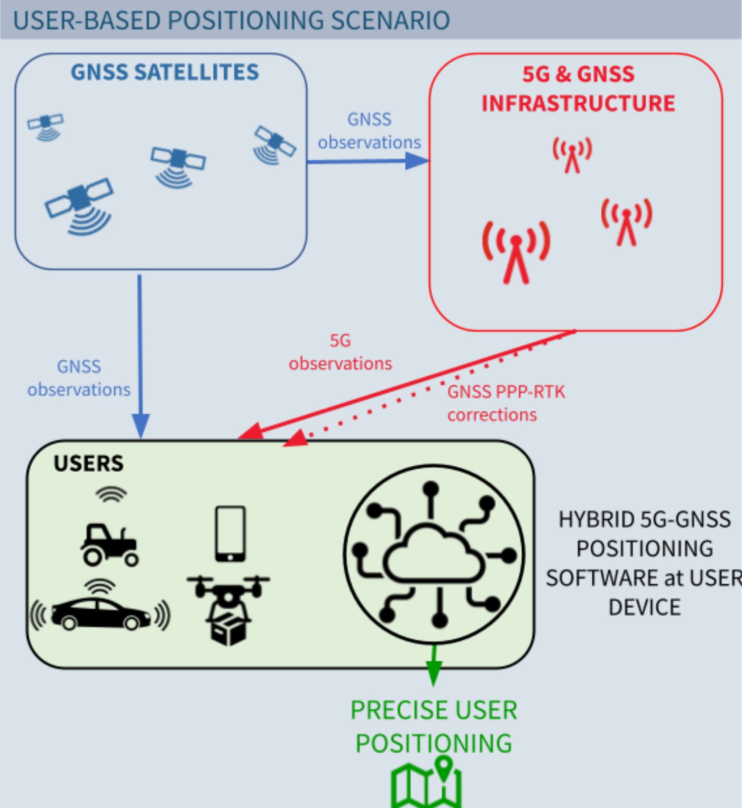
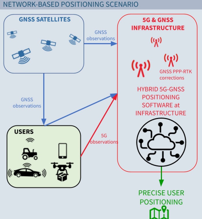
These three elements (GNSS, 5G and users) are the building blocks of the considered system architecture, and this project foresees two scenarios for the development and testing of the hybrid positioning engine. In the first one, referred as “user-based positioning scenario”, the algorithm for GNSS and 5G hybridization enabling precise positioning is at the user side, while in the second one, referred as “network-based positioning scenario”, the full positioning process is within the 5G & GNSS infrastructure itself. It follows that a fundamental difference is played by the GNSS PPP-RTK corrections which have to be sent (user-based positioning scenario) or not (network-based positioning scenario) over the 5G network. Another fundamental difference is that the precise positioning of the user’s equipment would be available only on the user’s side (user-based scenario) or also on the network side (network-based scenario). In both scenarios, the algorithms for hybridization of GNSS and 5G observations are customized, meaning that different implementations are possible and, most importantly, they can fit the specific hardware availability, guaranteeing updates over time. As a last comment, the functional building blocks represent standard equipments for a commercial device in the incoming years, as GNSS positioning is already a common feature of most end users products and the 5G connectivity should replace current older version of cellular communication (i.e., 4G, 3G, 2G).
user-based positioning scenario: HYPER-5G will be the first solution available on the market to achieve 5G-GNSS hybridization. The suppliers of localization technology will be interested in accessing the HYPER-5G product as soon as possible in order to stay in line with the state-of-the-art of top-edge localization solutions;
network-based positioning scenario: the implementation of HYPER-5G requires the usage of infrastructure-based 5G and GNSS data. Telecommunication service providers could be interested in aggregating both kinds of data by upgrading the exploitation of GNSS on their infrastructure beyond just timing applications. In this way, they could widen the portfolio of services they provide to customers by including high-precision localization.
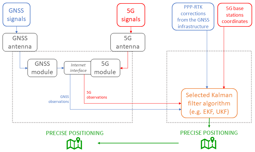
A preliminary functional block diagram of the envisioned hybrid positioning engine in the user-based scenario is reported below.
In this case, the fusion between the 5G and GNSS measurements carried out by the device to be localized with the data coming from the 5G and GNSS infrastructures is performed on board the device itself. The computed precise positioning will be available only at the device to be localized.
The proposed development activities aim at achieving a working prototype for the HYPER-5G hybrid positioning engine.
The expected Technology Readiness Level (TRL) by the end of the project is TRL 5.
The requirements for the product and its constituent parts are planned to be defined in WP H5G-011 “System requirements and KPIs”, that will take place in the first two months of the project.
A preliminary functional block diagram of the envisioned hybrid positioning engine in the network-based scenario is reported below.
By this configuration, the fusion between the 5G and GNSS measurements carried out by the device to be localized with the data coming from the 5G and GNSS infrastructures is performed on the infrastructure side. The computed precise positioning will be available to the infrastructure operator, and then sent to the device to be localized.
HYPER-5G hybrid positioning engine prototype
March 2022 - February 2024
Costs: ~500 K€
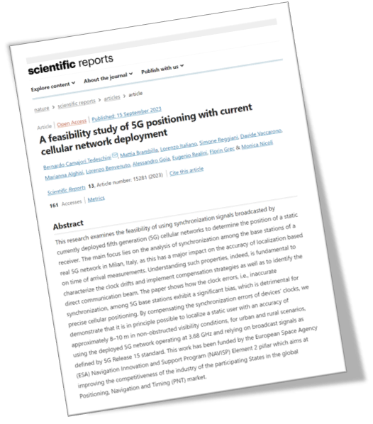
Camajori Tedeschini, B., Brambilla, M., Italiano, L. et al. A feasibility study of 5G positioning with current cellular network deployment. Sci Rep 13, 15281 (2023)
https://doi.org/10.1038/s41598-023-42426-1
The HYPER-5G consortium is actively collaborating with:
Vodafone Italia – in the collection of 5G signals broadcasted by real base stations, to derive ranging observations;
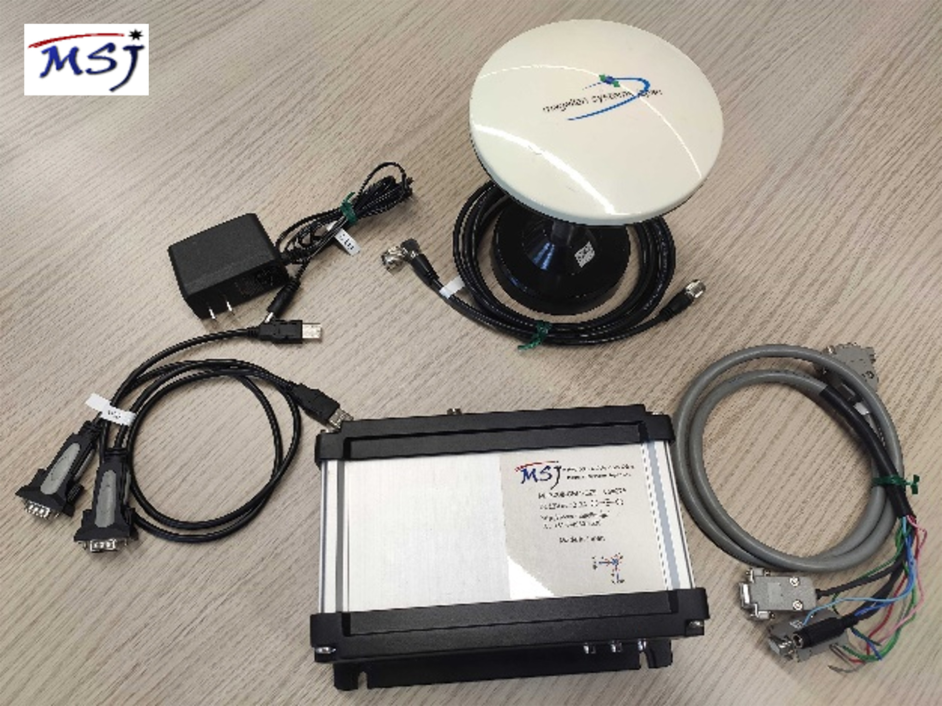
Magellan Systems Japan – in the collection of multi-constellation, multi-frequency GNSS observations from new-generation cost-effective receivers and antennas.

The image below shows the GNSS evaluation kit kindly provided by Magellan Systems Japan to carry out tests in the HYPER-5G project:
GReD Srl (coordinator) : SME, spin-off of Politecnico di Milano university - Focused on R&D, innovative algorithms development and software implementation in the field of geodesy and geomatics - 15+ years of expertise in GNSS data processing for market applications.
Politecnico di Milano : largest technical-scientific university in Italy, ranked among the top 20 universities in the world - IoTLab: interdepartmental laboratory (DIG and DEIB) focused on the development and innovation of products, services and processes in different vertical sectors of the Internet of Things, ranging from industrial IoT to smart mobility, up to 5G exploitation and smart city - Department of Civil and Environmental Engineering (DICA): historically, many of the experiences carried out by the "Geodesy and Geomatics" area represent important innovations at national and international level in the field of survey methodologies and navigation based on Global Navigation Satellite Systems (GNSS).
algoWatt SpA : SME with over 200 employees located in 7 offices in Italy - System integrator of solutions for the management of energy and natural resources - Fields of applications: digital energy and utilities, smart cities & enterprises and green mobility.